Many of you have followed the Goose Creek debacle for years and no doubt many feel the issue dead. Offered here is proof of the ongoing incompetence at the county level and beyond. For years the county has tried to essentially steal (words of one property owner), bluff or litigate into submission property owners across the northern part of the county who have the misfortune to own property on an abandoned rail route. The county owns the right to portions of an old rail bed, purchased for the gravel to be used by the county engineering department. At least that was the initial claim as again there has been an issue with a bike trail for just about as long as the county has owned portions of the right-of-away. I say “portions” as the county has been defeated in court at least three times by property owners who have secured the right-of-away back. The original paperwork showed essentially that the right of way was valid only as long as it was used for a railroad and reverts back to the property owner when that rail is no longer used or owned for that purpose.
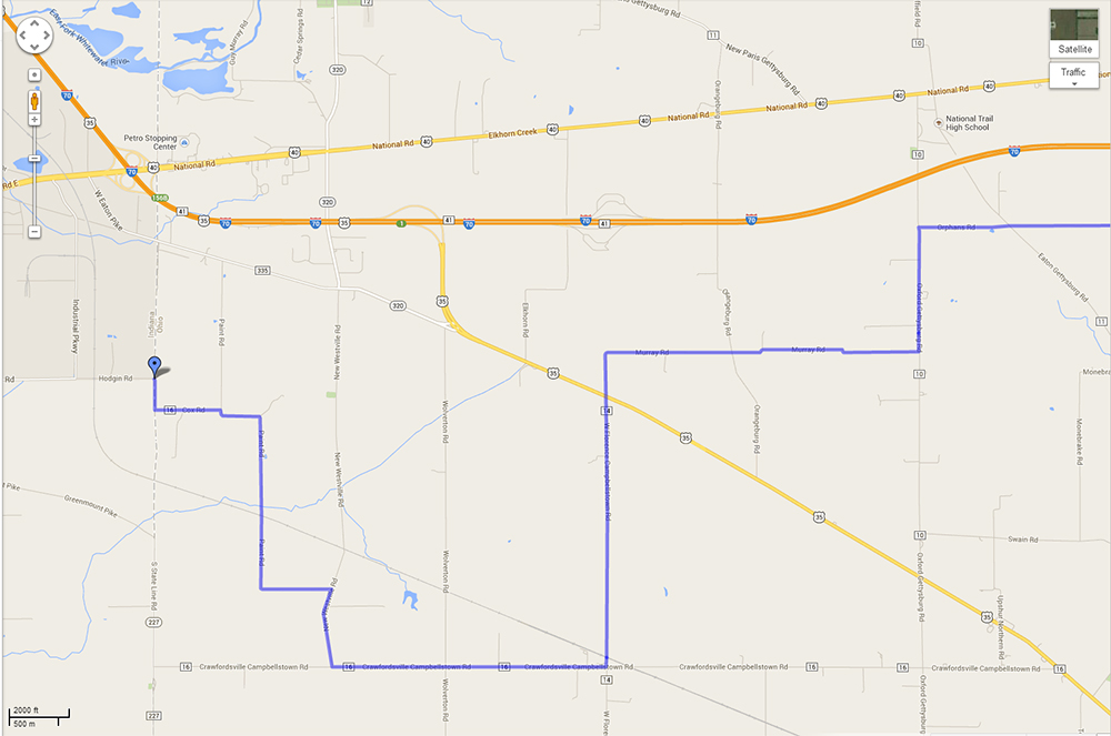
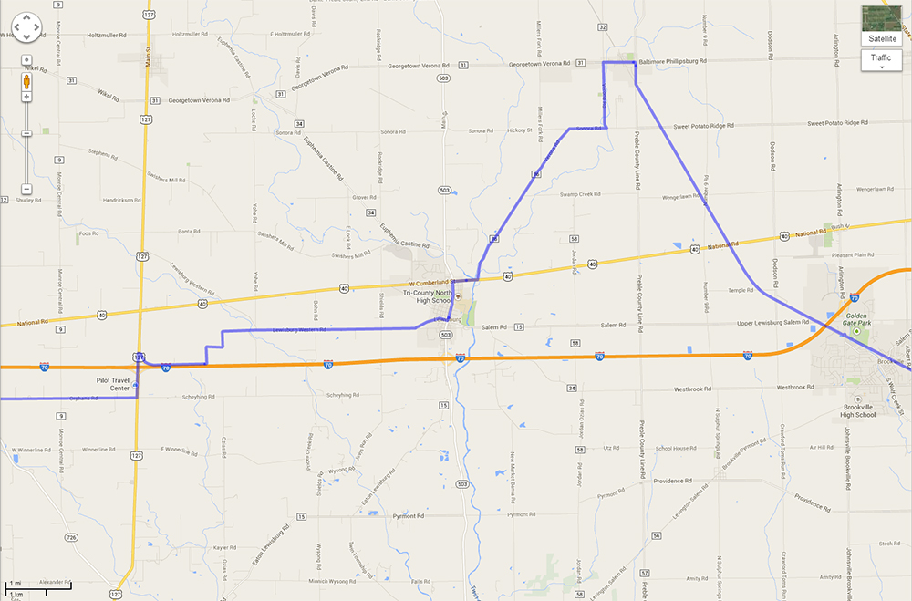
Take a look at this convoluted route across Preble County. You will notice that it does not make use of Rt. 40 which is the traditional route used by bike riders. The route ignores New Paris where there is lodging and two campgrounds as well as Eaton for country roads to the south and north. The issue is that any claim to the route shown below being safer is obviously proven false by routing future bike riders up Rt. 127 through the area of Goose Creek and the heavy truck traffic at the Exit 10 interchange.
This route across Preble County needs to be redone.
U.S. Bicycle Rt. 50
http://www.dot.state.oh.us/Divisions/Planning/SPR/bicycle/Pages/USBR-50.aspx
The American Association of State Highway and Transportation Officials (AASHTO) has designated a west-east corridor crossing the center of the state to be developed as United States Bike Route 50 (USBR 50). USBR 50 will be part of a national network of bicycle routes, which will link urban, suburban, and rural areas using a variety of existing cycling facilities.
Bicycle tourism is a growing industry that contributes $47 billion a year to communities that provide these facilities. A national bike route designation is expected to draw experienced riders from throughout the country, and connect scenic, cultural and historic destinations and attractions.
USBR 50 will go from California to Washington D.C. In Ohio, USBR 50 runs from Paint Road in Preble County at the Indiana border, through 11 counties[i]. The route passes over to West Virginia on the Market Street Bridge in Jefferson County. Nearly 40 local jurisdictions across Ohio have provided resolutions of support for the route.
Indiana and West Virginia are concurrently working to designate their respective portions of USBR 50. All three States have agreed to the route where the states meet.
To date, 5,973 miles of U.S. Bike Routes have been established in 12 states: Alaska, Kentucky, Illinois, Maine, Maryland, Michigan, Minnesota, Missouri, New Hampshire, North Carolina, Tennessee, and Virginia. Currently, more than 40 states are working to create U.S. Bicycle Routes.